
Snow depth is observed daily, both manually and automatically, at stations throughout Norway. At cryo.met.no we have now further developed a product that shows the current snow depth (starting 1st september every year) in relation to previous years and all-time highs and lows.
This is an operational service where the figures are continuously updated with completely fresh data. In addition to presenting the daily snow depth, the figures show the snow depth variation in the current winter and how the current season relates to the normal period 1991-2020 (see fact box below). For stations established after 1991, shorter periods have been used. In addition, you can see how the current winter compares to the most snow-rich and snow-poor winters in the entire measurement period at the station. If a new record high or record low snow depth has been observed during the current year, days with new records are marked.
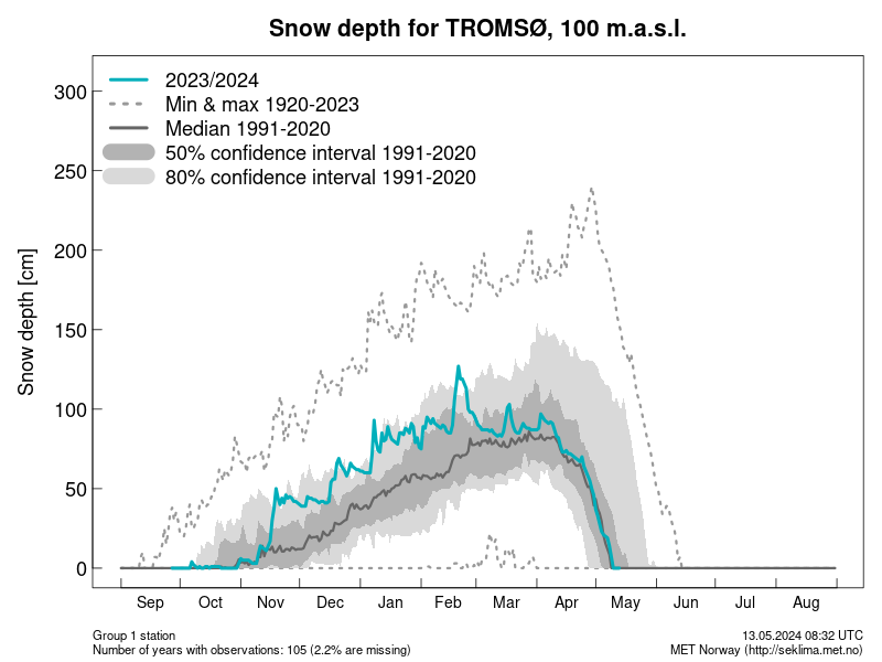
So far, we only show a selection of stations that measure snow depth in Norway. More stations will be added later in 2020.
See the new figures here
Snow depth data can be downloaded from seklima.met.no and frost.met.no
Fact box
Climatological standard normals are averages of climatological data computed for the most-recent 30-year period finishing in a year ending with 0. They form a benchmark or reference against which conditions (especially current or recent conditions) can be assessed and are widely used as an indicator of the conditions likely to be experienced in a given location. From 2021 onwards, the new international standard is the normal period 1991–2020. For this period, the various meteorological institutes calculate average values for a number of weather elements, for the largest possible number of stations. Normals are also calculated for stations that have not been in operation for the entire 30-year period.