
SIRANO in short
|
Research Objectives
In the Arctic, around Svalbard and in the Barents Sea, sea-ice moves every day, because the temperature and wind change. We use pictures from many satellites to tell where the sea-ice is every day. We also use computer models to tell where sea-ice will be in the next couple of days (like the weather forecast on Yr, but for sea-ice). But it is more difficult to predict sea-ice than wind and rain, and we need to do some research to make better sea-ice forecasts.
In our project, we will perform this new research. Three things that must be improved are: 1) to use satellites better individually, each on their own; 2) to use the satellites better all together; and 3) to use the satellites better together with the forecast models.
The main difficulty is to combine pictures from several very different satellites. For example, a type of satellite we want to use (Synthetic Aperture Radars) sees many details, but the pictures are hard to understand by a computer algorithm, and there are data gaps. Another type of satellites (MicroWave Radiometers) does not see the small details, but can easily be interpreted by computer algorithms and takes many images a day. How can we build a third satellite picture, that will combine the pictures from these two satellites well? This is one of the questions we must answer.
When we are done with our research, Norway will have new methods to use satellites and computer models to tell you where the sea-ice is, and where it is moving to. This is very useful for ships sailing or fishing around Svalbard, and for the Search and Rescue teams if there is an accident. It will also improve the weather forecasts we prepare for Yr.
SIRANO has three overarching objectives:
- To develop improved algorithms for measuring sea-ice concentration in the Marginal Ice Zone (MIZ), and prepare for future satellites (CIMR, cimr.eu);
- To improve methods for synergetic use of PMW and Synthetic Aperture Radars (Sentinel-1 SAR), aiming at sub-km scale resolution sea-ice maps;
- To start upon the transition from assimilating gridded daily maps (Level-3) to using each satellite orbit (Level-2) when initializing forecast models.
|
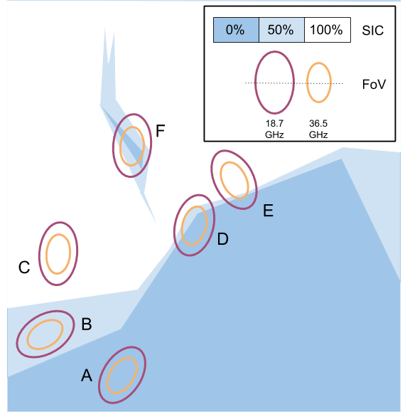
OBJ-1 : Improved algorithms for PMW retrievals in the MIZ. SIC retrieval algorithms using Passive MicroWave (PMW) satellite data are based on the contrast in emissivity (ε), and thus brightness temperature (TB), between open water (low ε, low TB) and sea-ice (high ε, high TB). The contrast depends on frequency, polarization, and type of sea-ice observed, and is generally larger at lower microwave frequencies (e.g. L-, C-, X-band) than at higher frequencies (e.g. Ku-, Ka-, and W-band). Algorithms that combine several frequency channels (e.g. Ku together with Ka) generally achieve better accuracies than mono-frequency algorithms. However, the different frequency channels of PMW satellite instruments (e.g. SSM/IS, AMSR2, CIMR) do not have the same spatial resolution: they do not observe the same area of the Earth surface, and thus potentially not the same sea-ice concentration. When this happens, there is a footprint-mismatch error. Fig 1 (left) illustrates three cases of footprint-mismatch (D, E, and F) in case of sharp gradients in the sea-ice cover. This footprint-mismatch increases the retrieval uncertainty in the Marginal Ice Zone, but there is no known analytical solution to this problem. In SIRANO, we will investigate how footprint-mismatch impacts the SIC and its uncertainties in the MIZ (OBJ-1). New insights in how to optimally combine microwave channels to achieve best accuracy and spatial resolution will be highly relevant when designing algorithms for future satellite missions, such as the Copernicus Microwave Imager Radiometer (CIMR, cimr.eu). |
|
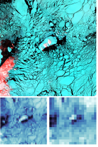
OBJ-2 : Optimally combining PMR and SAR for sub-km scale sea-ice information. Microwave Radiometry missions (like AMSR2, CIMR) allow quite accurate quantification of sea-ice concentration (<5% SIC standard deviation) depending on the microwave channels entering the algorithms (see OBJ-1). But the resolution is rather coarse (at best ~5 km) and does not meet the requirements of several user communities, including in-ice navigation. Another class of microwave imaging instruments are the Synthetic Aperture Radars (SAR). The SAR instruments offer high spatial resolution (~80 m for the Sentinel-1 missions) but the retrieval of sea-ice suffers from ambiguities (e.g. to wind, to newly formed sea-ice) that challenge the automatic retrieval of sea-ice parameters from the SAR signal alone. In SIRANO (OBJ-2), we want to further explore how passive microwave radiometer signal can be combined with SAR imagery to retrieve accurate and high spatial resolution sea-ice observations. The merging algorithm will involve a Data Assimilation framework and use satellite simulators (aka observation operators, right). |
|
|
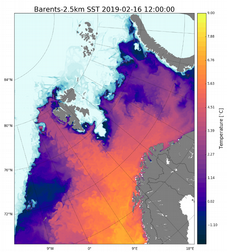
OBJ-3 : Use orbit-based (Level-2) data in ocean/ice forecast models. Today, the vast majority of ocean and ice forecast models ingest sea-ice concentration data from microwave radiometer to improve the accuracy of their forecasts. By commodity, they wait for daily averaged maps (Level-3 or Level-4 information) to be prepared, and do a daily (sometimes weekly) Data Assimilation step, followed by a forecast. In the case of sea-ice, this is however sub-optimal in several aspects, including:
In SIRANO (OBJ-3) we will investigate if some of the challenges listed above can be avoided by directly assimilating sea-ice information from the individual orbits (Level-2 information). We will study assimilation of Level-2 sea-ice information in the operational ROMS/CICE setup of the Barents Sea (2.5 km grid), with an Ensemble Kalman Filter (EnKF) framework (left). |
Implementation
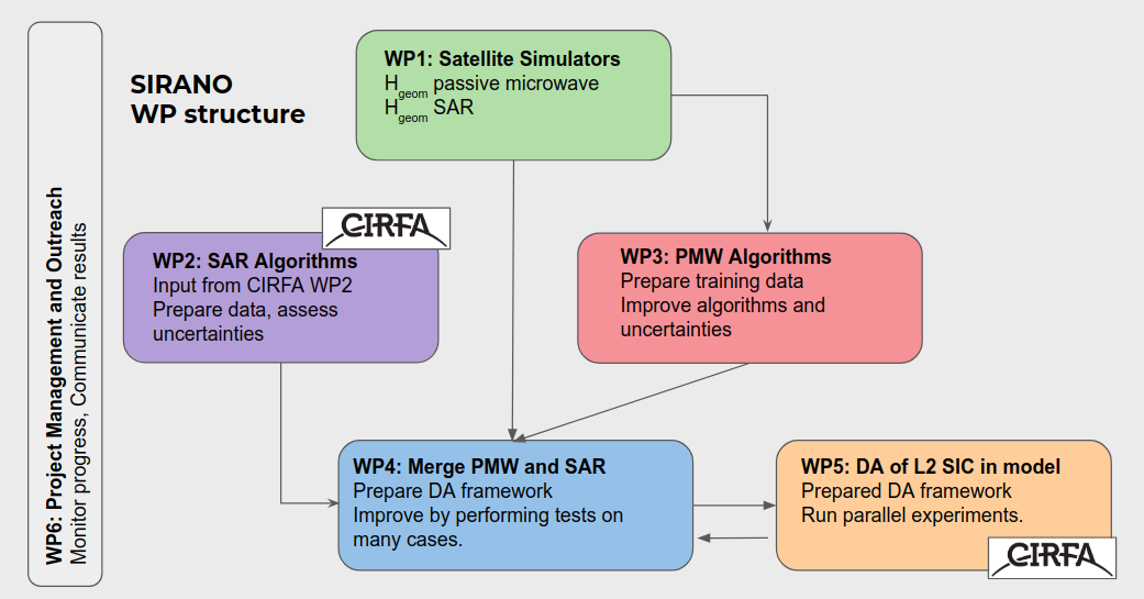
SIRANO is a 4-years (2020-2024) project funded by the Research Council of Norway. The project is led by the Norwegian Meteorological Institute (MET Norway), and University of Tromsø (UiT) is a partner. We have strong links with the Centre for Integrated Remote Sensing and Forecasting for Arctic Operations (CIRFA, https://cirfa.uit.no/). SIRANO is composed of 6 Work Packages (see figure above).
Have a question about the project? Please contact us.
